Israel annexed West Bank’s largest park and ‘is turning it into a Disneyland’
Israel is developing the Nebi Samuel national park while ignoring its Palestinian villagers, who aren’t allowed to have plumbing or plant trees
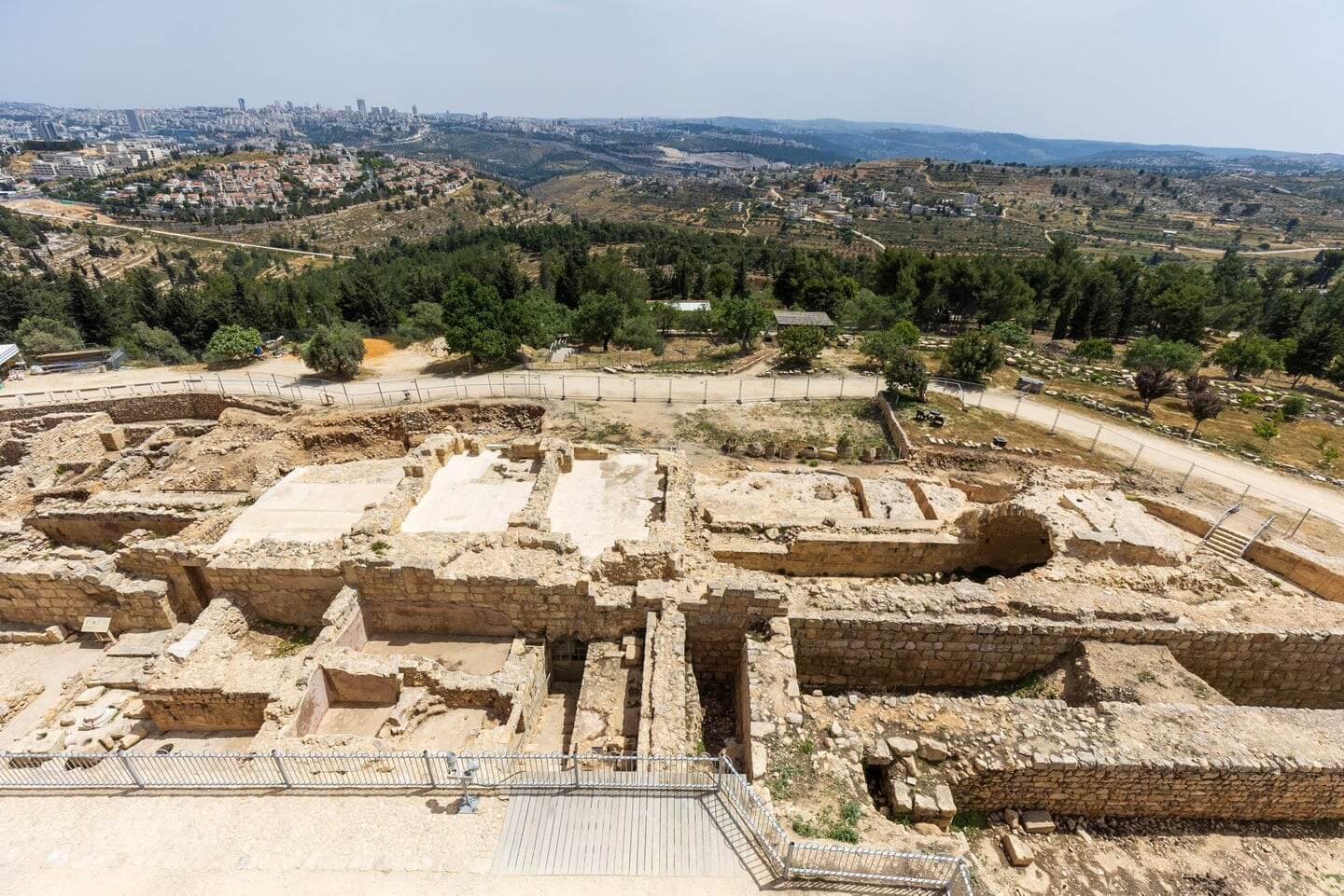
An aerial view of Nebi Samuel national park. (Emil Salman)
This article originally appeared on Haaretz, and was reprinted here with permission. Sign up here to get Haaretz’s free Daily Brief newsletter delivered to your inbox.
The view from the rooftop of Nebi Samuel’s largest building is incredible. From 884 meters (half a mile) above sea level, the city of Jerusalem appears almost within reach. The southern side of this rooftop in the archaelogical park allows a view of the Strings Bridge at the entrance to the capital.
From another corner, the golden domes of the Ein Karem neighborhood come into view. Looking northward, the cityscape of Ramallah is visible. The western vantage point includes a good portion of the coastal plain and the city of Modi’in. To the east are Palestinian villages, Israeli settlements, red roofs, and vast open spaces.
A metal railing surrounds the roof, adorned with informative plaques detailing villages, natural landscapes, and significant structures, Israeli and Palestinian alike. The neighboring settlements of Givon Ha’hadasha and Givat Ze’ev are in close proximity to the Palestinian town of Beitunia, with the East Jerusalem neighborhood of Beit Hanina not much further. It’s a mystifying geographic puzzle. Even recognizing the places on the plaques is a challenging effort.
Turning my gaze to the immediate surroundings when I visited, a large herd of sheep grazed beyond the park compound fence. The homes of Nebi Samuel are clearly visible beyond part of the fence. Beneath is a Crusader hall with magnificent stone arches. A stone staircase leading to the rooftop observation point stretches along the hall’s eastern wall, beside a still-functioning mosque. Beneath, one level below ground, is a synagogue that was thronged with visitors on the day of my visit. The white curtain of the ark at the synagogue asserts that this is the tomb of the biblical prophet Samuel.
The feast of the prophet Samuel is held in late Iyar, which is usually around this time of year. Recent years have seen attendance at the festival reach some 50,000. It’s thought to be the second-largest religious festival in Israel, after the one at the tomb of Rabbi Shimon Bar Yochai at Mount Meron.
All over the archaelogical park, the results of lengthy excavations done in recent decades are evident. Particularly striking is the Hellenistic area, with its extraordinary streets, public structures, and homes. On the other side of the compound, a path leads to “Hannah’s spring,” named after Samuel’s mother.
Whether this is indeed the tomb of Samuel, is a tricky question. This is a figure who ostensibly lived in the 11th century BCE – 3,200 years ago. The oldest archaelogical findings from the site are the remains of a Persian-era settlement from the 6th-4th centuries BCE, however.
The excavations also revealed structures from a large residential area from in the 2nd century BCE, during the Hasmonean era. This area was abandoned during the reign of Alexander Jannaeus (aka King Yannai) who ruled over Judea in 103-76 BCE.
Christian sources have linked the site to the biblical site of Ramah in the ancient region of Benjamin – and hence Samuel’s burial place. The more commonly accepted connection today suggests that Nebi Samuel is actually Mizpah, which is mentioned in the Bible as the town in which it was the prophet Samuel who was active.
Nebi Samuel became an important Christian site during the Byzantine era, when the tradition took hold that this was Samuel’s old stomping grounds. Samuel is an important figure in Christianity, having anointed King David, a forefather of Jesus. Muslim forces wrested control of Nebi Samuel from the Byzantines in 638 CE. They noted that the place was known as Deir Samuel – meaning the Monastery of Samuel.
In the 12th century, the Crusaders built a fortress containing a large church, a monastery, and lodging for religious pilgrims. Remains of the deep moat that surrounded it are still visible. The entrance hall has retained its domes and massive walls, and the church building also shows the remains of a 14th-century Mamluk mosque.
New history
In World War I, General Edmund Allenby tried to capture Jerusalem from the north. Nebi Samuel served as a key position in his campaign against the Ottomans. In November 1917, the area saw heavy battles, damaging sites. Jerusalem was only taken a month later.
In Israel’s War of Independence, the Palmach’s Harel Brigade, commanded by Yitzhak Rabin, tried to take the village. Fighters were thrown back with heavy losses, and the location remained under Jordanian control until 1967.
Up until then, the mosque and tomb had been surrounded by the village of Nebi Samuel (A-Nebi Samuil in Arabic). The village was home to over 1,000 residents. Most fled during the Six-Day War and were then not allowed to return to their homes. In 1971, Prime Minister Golda Meir ordered the military to demolish the village’s 46 homes. Some 250 residents from 20 families who lived in the village were evacuated to houses around 100 meters east of the mosque and archaeological site.
An article by Yuval Avraham published on the Sikha Mekomit site revealed State Archives documents showing that the homes were demolished in order to build a town of some 1,000 villas for Jews “of means.” The documents read, in part: “Golda Meir, who approved the expulsion and demolition of the residents’ homes in a classified 1971 document, called the Jewish settlement scheduled to replace the village with ‘another Savyon,’” referring to central Israel’s most affluent suburb at the time.
Shortly after Meir’s comments, soldiers gathered the remaining residents into a few stone houses belonging to Palestinians who fled in 1967. All other structures were demolished . According to some claims, the residents were offered monetary compensation to leave the area completely, and declined.
In June of 1972, the Israel Land Administration presented a plan for a settlement at the site that included 1,400 lots, public facilities, commercial centers, and roads. According to Avraham’s article, just three months after the Palestinians’ expulsion, hundreds of Israelis signed up to buy a lot in Nebi Samuel. The list of applicants runs 663 names long. Even Habima, the national theater, asked to buy a lot there.
The planned settlement never materialized. Environmental organizations opposed the construction, which they said would be a blight on the landscape. Jerusalem Mayor Teddy Kollek ordered that Nebi Samuel become part of a green ring surrounding the city. However, it became clear that the area was private Palestinian property. Then-Attorney General Meir Shamgar explained at the time, in 1973, that “If the owners of the land are present, it cannot be appropriated.” Those present are the residents of Nebi Samuel, who remained living near the site.
Twenty-two years later, two weeks before the signing of the Oslo II Accords, someone in Jerusalem recalled the nearby village, situated a kilometer from the city, and decided it was time to create facts on the ground. The prime minister then, 1995, was Yitzhak Rabin. In a move that today seems like a simple land grab, Nebi Samuel was declared one large park on September 17. The Oslo II Accords, dividing the West Bank into areas A, B, and C, were signed on September 28. Nebi Samuel and its environs were designated as Area C – under full Israeli control.
Haaretz reporter Amira Hass explained to me this week: “Creating the national park was an admission that the land couldn’t be taken over. When they recognized the fact that the area couldn’t be taken over and built on, they pulled a political trick, making it so nobody could build there. They effectively created a Disneyland there and even took off the Nebi Samuel sign. They created another Jewish enclave in the West Bank.”
Hass is clear that the main motivation for this was the desire to prevent a contiguous Palestinian territory south of Ramallah, and prevent the development of the village, which she says had great potential.
The place is called a park because it’s in the West Bank and administered by the Civil Administration. National parks can only be declared within Israel, but the rules at this park are identical to those at national parks. The declared site includes not just the hill with the Crusader hall and Samuel’s alleged tomb. These only take up 52 dunams (13 acres). Nebi Samuel National Park stretches over 3,500 dunams (865 acres). Thus was created one of the largest parks in Israel, and the largest in the West Bank.
In comparison, Masada National Park stretches over 2,700 dunams. Ashkelon National Park encompasses some 3,000 dunams. Gan Hashlosha National Park, better known by its Arabic name, Sakhne, only takes up 140 dunams. The total area of the Jerusalem Walls National Park is 1,100 dunams. Herodion National Park is 1,000 dunams. Sebastia National Park, the renovations of which the government approved to the tune of 34 million shekels ($9.1 million) just this week, lies on only 214 dunams. Nebi Samuel’s 3,500 dunams dwarfs these.
The result is a national park in which several hundred people reside. Within Israel’s borders, there is no national park in which people reside. In the West Bank there are two other such examples – one in Herodion, where several Palestinian families live, and in the City of David area, which is in the middle of the Jerusalem neighborhood of Silwan.
The meaning of life in the middle of a park or national park is difficult – nearly impossible, in fact. Residents can do virtually nothing to improve their lives. They can’t build or develop anything. They can’t plant trees, lay sewage lines, or put up a fence.
The situation in Nebi Samuel is even more complex. Since the separation barrier was built two decades ago, the residents have been completely shut off. The fences of the site separate them from the rest of the West Bank. Despite that, they are Area C residents, and therefore banned even from entering Jerusalem without a special permit.
Hass calls this a “permit regime piling endless obstacles, intended to expel the residents from the village. That’s how they created a large area, from Ramot to Modi’in, that has become ‘cleansed’ of Palestinians.”
Idan Landau is a professor of linguistics at Ben-Gurion University of the Negev in Be’er Sheva and an anti-occupation activist. Nine years ago, he wrote on his blog: “The 250 residents of the village, lying only one kilometer north of Ramot neighborhood in Jerusalem, are living in an intolerable cage. They are formally Palestinian Authority residents of Area C; in practice, they are cut off from the West Bank by the separation barrier, as well as the apartheid road, Route 436, which connects Ramot to Givat Ze’ev. Another Palestinian community is trapped in this enclave, Al-Khalayleh, located below the settlement of Givat Ze’ev, but it is at least spared the punishment of being a ‘national park.’ This level of bureaucratic abuse is unknown to me in the regions of Judea and Samaria.”
Later on, Landau adds: “They call it creeping expulsion. Bureaucratic, persistent, incessant. In fact, to the authorities this is nothing but a virtual village, a mirage from the past. During a hearing on objections to the creation of the tourism project at Nebi Samuel, the Civil Administration representative stated that ‘there is no village – there is a park.’”
Nine years have gone by. Reality appears different. There is a park with a village inside it.
Seeing that this situation has been ongoing during the 28 years since the park was established, I wasn’t surprised when none of the villagers agreed to speak with me – a bespectacled Israeli, wearing a blue hat with pineapples on it. At the local grocery, where I bought a bottle of water, one of the residents agreed to answer my questions about life in the village with six isolated, suspicious statements: “It’s tough,” “What can I tell you?” “That’s life,” “We’re here,” “We’re not leaving,” and finally, “Take care.”
Erasure action
Two years ago, the Civil Administration’s Higher Planning Council approved the Nebi Samuel development plan. Most of the plan pertains to the archaelogical site, and includes the construction of a restaurant and an information center. The development plan completely ignores the village and its residents.
Archaeologist Gideon Suleiman is a member of Emek Shaveh, an organization that fights against the use of heritage sites and archaelogical remains as a tool in the Israeli-Palestinian conflict. He told me that as a result of archaelogical excavations in the 1990s, the remains of the old village have been completely destroyed. “The archaelogical excavation was an act of erasing of the village to uncover older remains, and that’s what they show visitors today. All residents of the village are trapped within the national park. The separation barrier that was constructed was the most dramatic step. It doesn’t conform to the Green Line. They de facto annexed a piece of land here. Because of the contours of the barrier, they essentially can’t move in any direction.
“The entire site is intended for Jews,” Suleiman says. “Most visitors don’t actually see what’s going on there. They see a pretty archaelogical site. They’re not aware at all of the political status of the site, and the use of antiquities to erase the village. The known pattern is to take an ancient site, emphasize the historical Jewish narrative, and turn it into an Israeli site. At Nebi Samuel, because of the marking of the tomb of the prophet Samuel, there is additional sanctity that draws visitors. Emphasizing the Israeli connection allows for the Judaization of the site. That’s what they did at Shiloh, Susya, Sebastia. The Nature and Parks Authority is the pipeline for this activity.”
What’s the solution at Nebi Samuel?
“To repeal the designation as a national park. This will allow the residents to build. But the authorities want them to give up and leave. There have already been some residents who’ve moved to the West Bank. The young people can’t build and are forced to leave. Eventually, I assume, they’ll transfer those homes to Jewish ownership. These antiquities are a significant tool in this step. They create the narrative. A huge donation enabled the multi-million shekel restoration of the tomb.”
The Civil Administration has been in charge of natural and archaelogical sites in the West Bank for the past 57 years. Its website states, among the description of its duties: “Declaring nature reserves, parks, and protected natural assets, while maintaining and protecting them. Development and oversight of nature reserves and parks, and preparing them for receiving visitors.”
The website further states that “a site in which the Civil Administration has invested much resources in recent years is the tomb of the prophet Samuel. Preservation and development works were undertaken for the convenience and safety of worshipers of all faiths who visit the site.”
Miri Altshuler has served as the director of Nebi Samuel Park for the past two years, at the unit of the Parks and Nature Authority staff officer at the Civil Administration. In a conversation with Haaretz, she described the site as follows: “Nebi Samuel Park is a site combining nature, landscape, and heritage. There are 3,500 dunams of natural space here. There’s a herd of 40 deer that roam the grounds. We’re on an avian migration route. The view from the observation point is incredible. There’s over 2,000 years of heritage here, from the First Temple era and throughout the ages, and all the stories of battles in World War I, 1948, the Six-Day War. It’s a site that’s sacred to Jews, to Christians, and to Muslims, and contains the tomb site of the prophet Samuel. There’s the mosque holding prayers several times a day, and at its entrance is the Crusader church.”
How many visitors come to the park?
“In 2022, 380,000 visitors entered the park. Entrance is free and the crowd is diverse. There are lots of groups of visitors from abroad. Many Christians from the United States, Muslims, and of course Jews. Many visitors hike on the park trails. You can walk here for five or six hours. Many ultra-Orthodox come not just to pray, but spend their time in the park.”
A village within a park doesn’t create a problem?
“I don’t think it’s a problem at all. On the contrary. The imam at the mosque lives in the village. His two sons work on the site’s staff. During the archaelogical excavations, around half of the village worked in excavations. There are good relations with the villagers. They also make money from visitors. When I entered the position, I had a dream of developing hospitality and tourism activities in the village, but it hasn’t happened yet.”
Why does the park need 3,500 dunams, if the archaelogical site occupies 52 dunams?
“That’s a good question. That’s what they declared years ago. The park has a lot of flora and fauna, and even more archaelogical artifacts. I think there’s great importance in the park’s very existence as a green lung near Jerusalem. The site preserves historical sites and nature in the area, and protects from construction. Besides, what would you do with the deer? Run them off? These are captive deer, and we also have a rescue nursery for plants in danger of extinction.”
A message from our Publisher & CEO Rachel Fishman Feddersen
I hope you appreciated this article. Before you go, I’d like to ask you to please support the Forward’s award-winning, nonprofit journalism during this critical time.
We’ve set a goal to raise $260,000 by December 31. That’s an ambitious goal, but one that will give us the resources we need to invest in the high quality news, opinion, analysis and cultural coverage that isn’t available anywhere else.
If you feel inspired to make an impact, now is the time to give something back. Join us as a member at your most generous level.
— Rachel Fishman Feddersen, Publisher and CEO


